Solving London’s urban flood problem – a landscape architecture approach
Tom Turner’s lecture was given to the London Parks and Gardens Trust on 21st June 2017. This post has an edited version of the text
Summary, Gentle rain, frightening floods and design of public open space
The Woolwich Flood Barrier was built after the North Sea Flood of 1953. But it has to be closed more often each hear and London’s flood indicating that the problem is worsening. We see flooding at Richmond, Strand on the Green, Greenwich and elsewhere. Thamesmead, with a 7m high wall is typical of the engineering solution. Landscape architects favour a policy of low impact development and Sustainable Urban Drainage Systems (SUDS). This includes green roofs roof gardens, as with University of Greenwich Stockwell Street Roof Garden. Metering wastewater and giving abatement discounts are also good policies. The Lost rivers of London should be reclaimed by daylighting and channel restoration, as was done for the Quaggy River in Sutcliffe Park and the River Ravensbourne in Brookmill Park. The Thames Tideway Tunnel is a waste of money, as Chris Binney argues. Integrated Catchment Management is a better policy, as Sarah Whatmore argues in response to the Babtie design for Pickering. This is the kind of policy Patrick Geddes argued for in India and Ian McHarg, the best known landscape architect of the 20th century, followed in Woodlands Texas. Lake Dal, Kashmir, and the Gruner See in Austria have inspiring ways managing floods. The Queen Elizabeth II Olympic Park could also have a flood detention storage lake. A Londonwide green roof policy should be adopted.

The urban flooding problem
At 885mm/year the UK’s average rainfall is pretty good. It’s not too high. London has 600mm/year, well below the world average of 990mm. So London should not have a flood problem. But it does and there are several theories about the causes:At 885mm/year the UK’s average rainfall is pretty good. It’s not too high. London has 600mm/year, well below the world average of 990mm. So London should not have a flood problem. But it does and there are several theories about the causes. There is speculation that as a city, London is particularly wasteful and citizens are flushing items that shouldn’t be flushed, such as tampons which lead to large blockages in the drains. If you think that your flooding issues might be caused by blockages, which might be very likely, especially if you live in an apartment, you can navigate to this website for some solutions. Here are some other theories regarding the causes behind the flooding:
- Too few drains – so that the water can’t get away
- Too many drains – which accelerate water run off
- Too many impermeable surfaces – so the water can’t seep into the ground
But we share an ancient Fear of Floods. The world’s oldest literary work: The Epic of Gilgamesh, sees floods as a punishment from the Gods. 2000 years later, in the Bible, they are a punishment from the one true God. I’ve never been in dangerous flood but, though I love swimming, I do have nightmares about drowning. A terrible North Sea Flood hit London in 1953. 307 British people died. None in London. One 1 in Kent. The causes of the 1953 deaths were that dykes had not been repaired during the war and that there was no early warning system. A barrier was built at Woolwich and most of London was protected.Engineers have have responded to fears about flooding with drastic measures. So let’s look at the River Thames flood walls as an engineer might look at them.

Urban flooding in Richmond
A river wall was built at Richmond in the 16th century, when Henry VII built a palace here. Since then, the poor cash-strapped residents have never had enough money for proper flood defenses. At each Spring Tide, we see scenes reminiscent of what happened after the Titanic hit an iceberg. To begin with, the music keeps playing while men, women and children keep smiling.They know nothing of the coming flood. Then, in an instant, the bank sitters have all gone. With traditional British sang froid, the brave folk of Richmond keep on smiling. Some use benches as lifeboats.
Urban flooding in Strand on the Green
At Strand on the Green there are similar scenes of tragedy. Look at the poor doggie. I called the RSPCA. But the horror was too great and I fled the scene before they arrived. That man could so easily have rescued the doggie. Instead, it strides into the waves to meet its maker.Local residents, because of official neglect, have had to put up their own flood defences. You can see glass barriers, raised entrances, and watertight planking across the doors. Footing the bill for the flood defenses has likely reduced the cost of having to consistently call plumbers out like this one that are always helpful in these situations. Look those poor girls. No shoes, as in Dickens’ time. One’s heart bleeds for the residents. Their miserable dwellings are only worth a few million pounds each.
Urban flooding in Battersea
Battersea is a much older settlement than Richmond and the Victorians did a reasonable job of protecting the park from the river. They got rid of the nasty marshland weeds by tipping 3/4s of a million tons of mud (from the Surrey Docks) and protected the beach from the park with a reasonably sized flood wall. Commercial traffic made the beach dangerous in the 19th C and Weil’s disease make it dangerous. Each year 2 or 3 die in the UK. Antibiotics are the only treatment.The River Westbourne shows the safe way of treating a river. It removes water and harms no one. They did this to the in Cheonggyecheon River in Seoul. Unfortunately, the road was not built properly and they had to replace it with a park.
Urban flooding in Greenwich
Here’s the scene of some more horror. The waterfront in Greenwich took its present form at the end of the eighteenth century. Wren and Hawksmoor were OK as architects but through engineers’ eyes they were hopeless at flood defence. Look at the innocent victims being splashed. I have not read of them catching Weil’s disease but the police arrived soon after this video clip was shot and we have to suspect a cover-up. The problem is that the walk is only 4.4m above the Ordnance Datum, compared to 5.8m in most of Central London. And it’s only 1.5m wide – which is why it’s called the Five Foot Walk. Shocking.
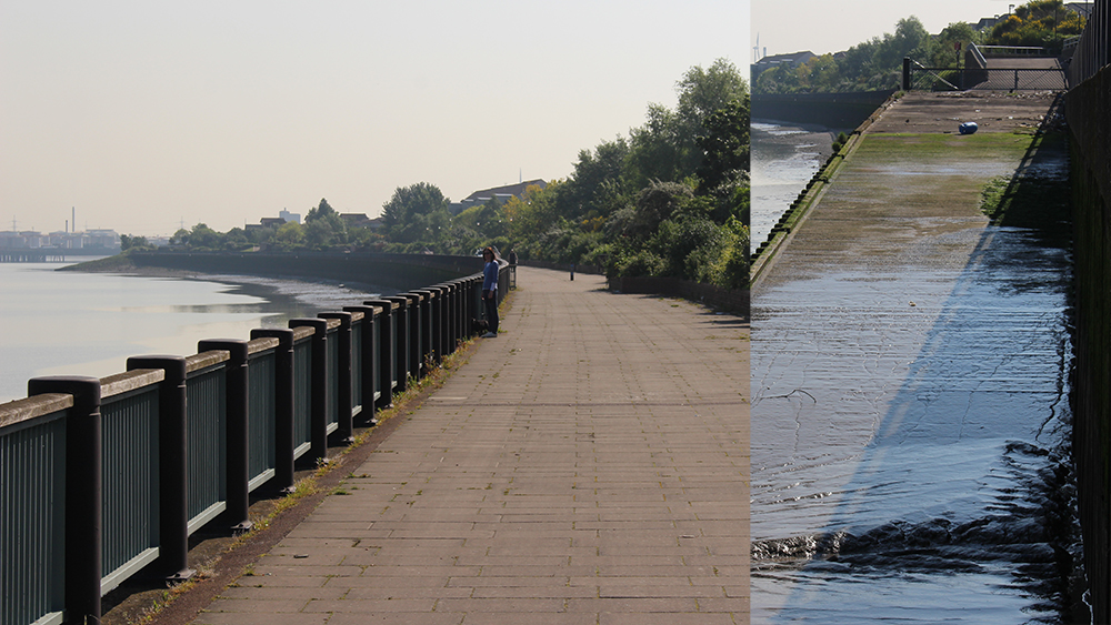
Urban flooding in Thamesmead
At Thamesmead the engineering profession has given us a brilliant example of what should be done upstream. The black and white photographs on the left show the flood wall before and after it was ‘landscaped’. As well as protecting local residents the flood wall has created a ‘charming’ new space and a ‘valuable’ recreational facility. We see modernist engineering combined with modernist design. It could serve as Britain’s answer to Hitler’s Atlantic Wall. The video clips show it on a busy day, in warm sunshine, and on a quiet day, in the rain. It’s a 7×7 wall: 7m above Ordnance Datum and 7m wide. This is obviously better than the dangerous and unpopular Five Foot Walk walk at Greenwich. I look forward to a similar treatment for the Seven Sisters (at Cuckhaven) which obviously need a protective wall.
Definition of public open space
Before reviewing how POS can help ease London’s flood problems, I’ll spend a minute on definitions. “Public Open Space” includes:Blackheath Common and Greenwich Park. They are examples of bound and unbound Public Open Space (POS)Greenwich Waterfront has greenway, mentioned above, which can flood periodically and make a useful contribution to the flood storage capacity of the River Thames.Greenwich also has green roofs. The University of Greenwich Stockwell Street building has both extensive and intensive green roofs. And there are private green roofs in Greenwich. Many buildings even have a foam roof underneath to help insulate the building, which means this isn’t sacrificed for the green roof option. It is all green space and it all has an impact on PUBLIC GOODS. So, with little more sarcasm at the expense of 20th century civil engineering, the rest of this lecture is about how the design and management of greenspace can lessen the risk of flooding. 21st century flood engineering is much more enlightened but still does not take sufficient advantage of POS. By ‘Public Open Space’ I mean all the space upon which the gentle rain falleth. I’ll start with four examples from Greenwich.
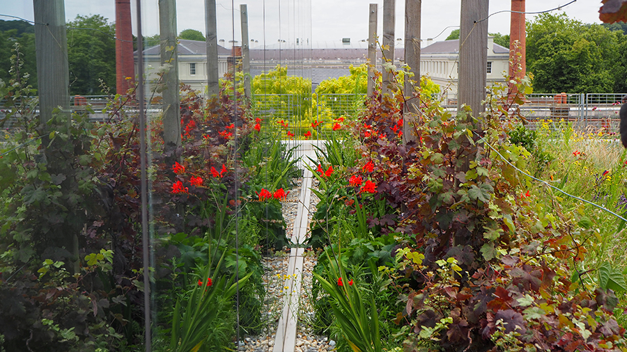
Stockwell Street Roof Garden in Greenwich
The first example is the University of Greenwich’s Stockwell Street Roof Garden. The original idea was for the whole roof to be extensive. The landscape staff argued that it should become a teaching resource and Dr Benz Kotzen is managing it for wildlife, vegetables, quiet study, aquaponics – and relaxation. If all London’s roofs were treated in this way the city’s flood problem would be greatly diminished. But there are two problems: storms from the North Sea surface waterrunoff from the land. Green roofs protect against runoff but not against storms. The Woolwich Flood Barrier, as mentioned, was built to protect against storm surges. To begin with, this was its use. Now, half its closures are to provide storage for water running off the land. This is because development projects are making more and more of London impermeable to the gentle rain.
A private green roof in Greenwich
This house was built in 1926. Most of the water that falls on the roof is infiltrated in the garden. When it rains after a dry period it is over an hour before any water runs off the roof – and none of this runoff goes into the drains. Greenwich Council used to say this was illegal. Thames Water now gives a ‘Wastewater Abatement’ discount if you do not use their drains. I’m glad they do this but they should meter, or estimate, the use of drains just as they meter water supply. They could send assessors round, as they have just sent round staff to advise on water supply meters. I was shown how to flush a toilet. The engineer could easily have made an assessment of surface water discharge at the same time. This would discourage people from paving their front gardens and encourage them to install rain gardens. Furthermore, environmental experts could also make use of EHS software such as risk assessment software to identify any potential hazards, assess the associated risks, and track any possible controls. By identifying hazards and assessing their risks using software, organizations such as water companies can avoid costly incidents further down the line.
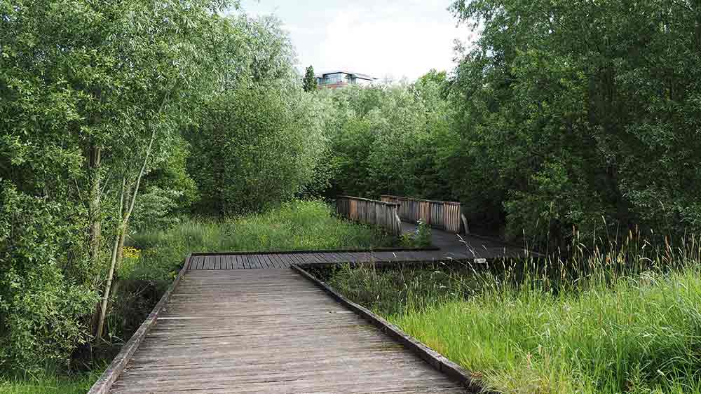
Sutcliffe Park river restoration and flood storage lake
Sutcliffe Park used to be a ‘classic’ municipal park with green railings and muddy grass, used by a few dog walkers most days and by a few footballers on Saturday mornings. The National Rivers Authority (which became the Environment Agency) was assaulted by complaints about flooding in the lower Quaggy River. It wanted to build flood walls through Lee and Lewisham. But was talked out of this by a group of local residents, and decided instead to use Sutcliffe Park for occasional flood storage. Congratulations to QWAG, the Quaggy Waterways Action Group.A former Greenwich landscape architecture student, Kevin Patrick, did the original design for Sutcliffe Park and I was cross at the time because Greenwich Council tried to block the project. It said the problem only affected residents of Lewisham. Then it demanded compensation for loss of football pitches. On reflection, I believe that the Council was right to ask for money but that it should not have been a one off payment for loss of football pitches. It should have been an annual payment for mitigating floods. I see flood management as a great role for parks and a great source of income for hard-pressed park managers.
Restoration of the River Ravensbourne in Brookmill Park, Lewisham
The River Ravensbourne was channelized in the 1950s & 60s. The first clip shows one of its more attractive sections – because you can see vegetation. As everywhere, this kind of flood defence passes the flood risk downstream. In the 1990s, when the DLR was extended to Lewisham, they identified part of this channel as an ideal location for a light railway. So a short section of the River, through Brookmill Park was ‘daylighted’. I think Atkins’ landscape architects did the design and apart from the bagwork, which must be an engineers’ idea, it’s very good. Brookmill Park makes a valuable contribution to flood storage upstream of the Woolwich Barrier.
Now let’s leave Greenwich and look at five other solutions to the problem of urban flooding
The Thames Tideway Tunnel
The Thames Tideway Tunnel is being marketed as a project to lessen sewage pollution. It will do this. But sewage gets into the Thames only because of London’s 19th Century shared sewers. If you took the surface water out of the old sewers there would be sufficient capacity for the foul sewage. Chris Binnie, the Chairman of the committee which proposed the Tideway Tunnel now thinks it’s a waste of money. The owners, who are an international group of investors, disagree. I can’t think why. But every household in London is going to pay £25/year to the investors for the rest of our lives. That’s why the UK is a great place to invest. I’d rather the money was spent on the approach called Sustainable Urban Drainage (SUDS) in the UK and Low Impact Development (LID) in the US.
Integrated catchment management as a solution to the flood problem
Sarah Whatmore, an Oxford geographer, has given several lectures of Living with flooding – a very good title. Her interest began with a 2007 flood in Pickering (south of the North York Moors).She worked with what became the Ryedale Flood Research Group. It persuaded the community to accept upstream detention instead of Babtie’s ‘imaginative’ proposal for Thamesmead-style flood walls in the midst of a historic town. The engineers, Susan Whatmore reports, had used off-the-shelf data and off-the-shelf software. Garbage-in>Garbage-out, is what the old proverb tells us. Water-in>Water-out was the proposed engineering solution. The Ryedale Group supports the flood policy landscape architects have been advocating for over a century. Geddes, when working in India, wrote that ‘Drains are for cities, not cities for drains’Ian McHarg (in Woodlands, Texas) wrote that ‘there is no better union than virtue and profit’.Here’s my version of Integrated Catchment Management, written in 1998. In all the industrial countries, ‘Forest clearance took place on the hills, in the valleys and on the plains. This accelerated water runoff. Ploughing and drainage took place in agricultural areas. This accelerated water runoff. River channels were deepened, widened, straightened and fixed. This accelerated water runoff. Large new urban areas were rendered partially impervious, with roofing and paving materials. This accelerated water runoff. The capacity of washlands and flood plains to accommodate peak volumes was diminished by building upon them.’ (Turner, T., Landscape planning and environmental impact design UCL Press, 1998 p. 294). Basically, engineers want to get water off the land and landscape architects want to keep water on the land.
Flooding in Kashmir
Lake Dal is famous for the houseboats used by tourists. They were popularised by the British, because the Donga King would not let them buy immovable property. It was traditional for lotus gatherers, fishermen and those who tended floating gardens to live in doongas. Those who cultivated the rich land on the shores of the lake live in 2-story houses. When the flood waters rise, maybe 1-3m, they move to a higher level. As we saw at Strand-on-the-Green, some Londoners have already learned to live with floods. It’s a cost-effective and attractive solution.
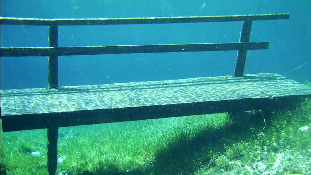
Flood storage in the Green Lake, Tragoess, Styria, Austria.
The Grüner See (Green Lake), like Lake Dal, it is surrounded by mountains. The water level rises when the snow melts. It is 1-2m deep in Winter and can rise to 12m in spring. This made it popular with scuba divers – until scuba diving was banned. The water is exceptionally clear and the lake’s name comes from its colour. Park managers are good at bans. Is there a London park might be suited to this treatment? The Queen Elizabeth Olympic Park is a possibility. I think Londoners would enjoy seeing the area flooded once or twice a year. And more flood storage capacity in the Lower Thames means less flood risk in the Upper Thames.
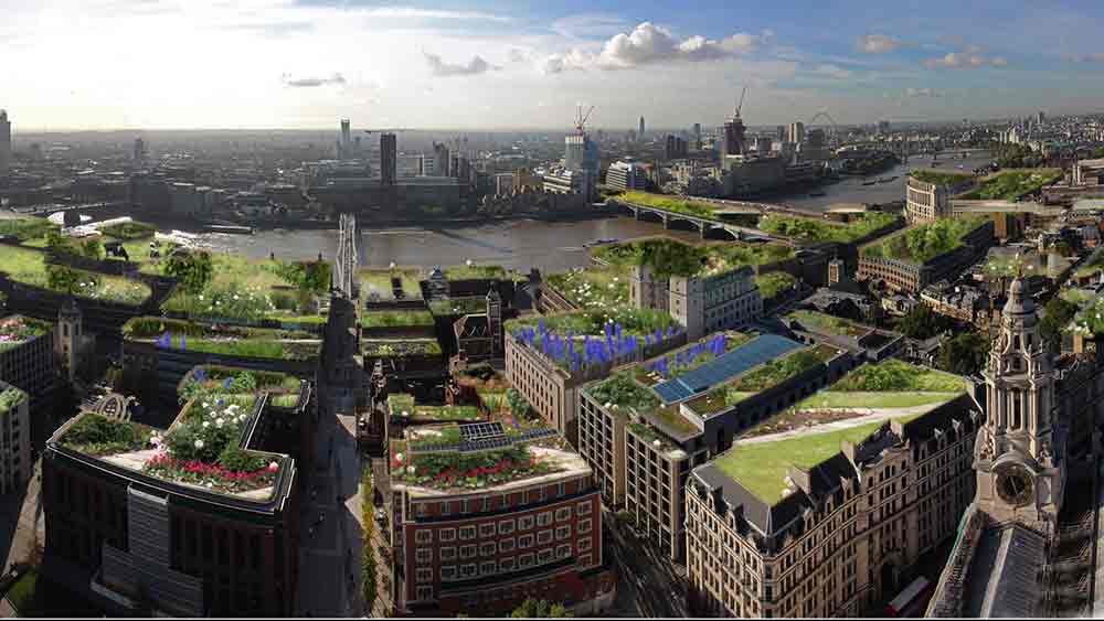
A green roof policy for the City of London
The US Environmental Protection Agency states that Green Roofs can REMOVE 50% of annual rainfall runoff and DETAIN the other 50%. So this is my proposal for a Skyscape Policy to diminish the risk of flooding in London. The idea is to detain and evaporate most of the Gentle Rain at rooftop level, so that the old sewers can be used for foul sewage only. Also, and in line with one of the key principles of landscape architecture, it’s a multi-objective project. It would:improve biodiversity by creating new habitatslessen air pollution by catching particulates save energy by insulating buildings create a quiet and sunlit world for office lunching capture carbon, and, of course save the planet Economists, I hope, would see these as positive externalities resulting from a flood management policy.
Conclusions on London’s flood problem
I’ll finish with two points illustrated by a clip from a 1958 British film: Floods of fear. First: we all understand that flooding is a serious problem. We may poke fun at engineers but we must all feel deep sympathy for flood victims Second: we all need to remember that much of London’s ‘flood problem’ is man made: all the scenes in the clip were shot in Pinewood Studios, as Howard Keel relates in his autobiography. I can’t imagine how they did it but am confident that implementing a Green Roof Policy for the City of London would be whole lot easier.
